


190-00498-07 Rev. A
Garmin G1000 Pilot’s Guide for Cessna Nav III
53
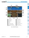
FLIGHT INSTRUMENTS
SYSTEM
OVERVIEW
FLIGHT
INSTRUMENTS
EIS
AUDIO PANEL
& CNS
FLIGHT
MANAGEMENT
HAZARD
AVOIDANCE
AFCS
ADDITIONAL
FEATURES
APPENDICES INDEX
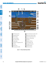
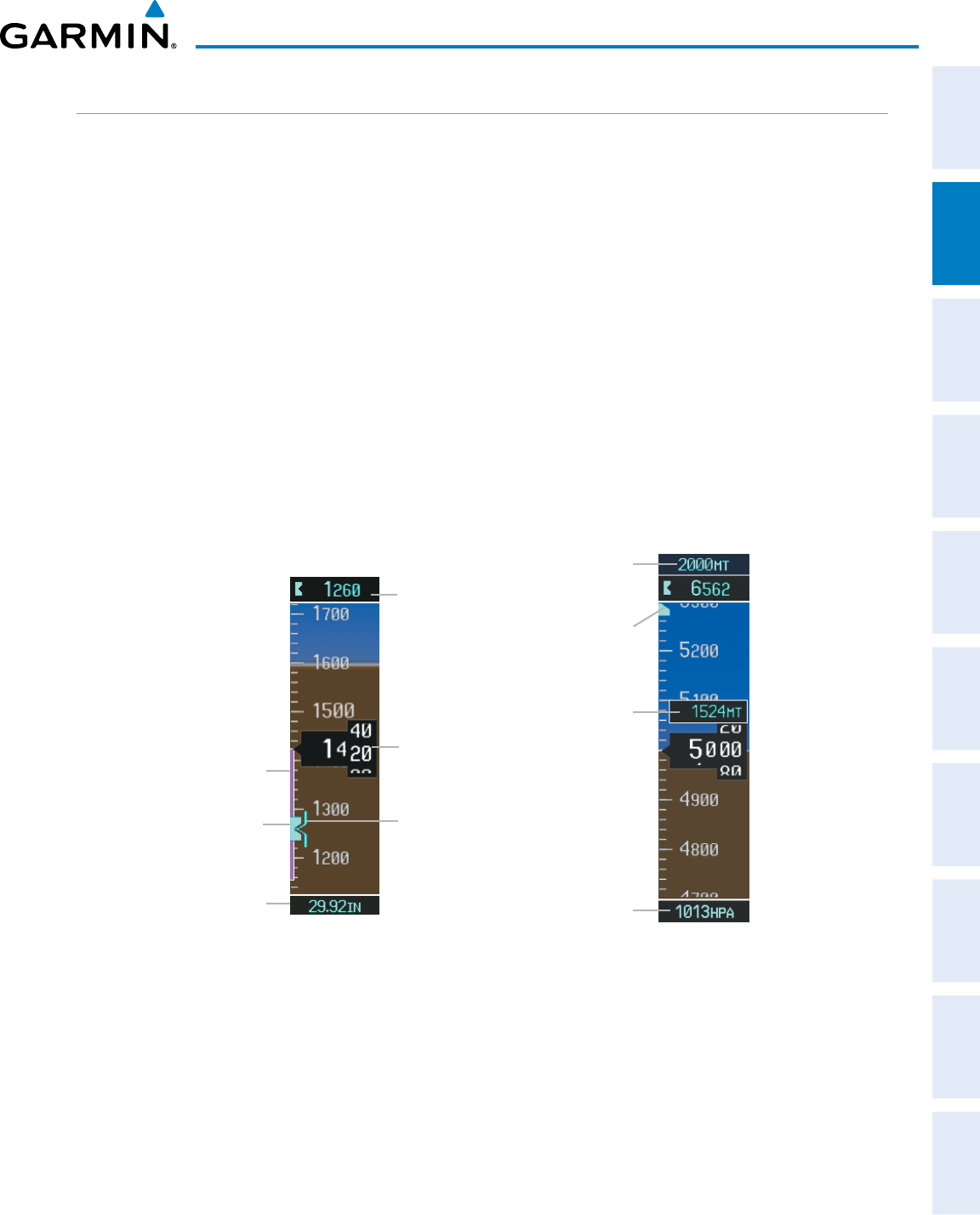
ALTIMETER
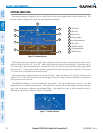
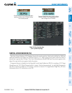
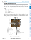
The Altimeterdisplays600feetofbarometricaltitudevaluesatatimeonamovingtaperollingnumbergauge.
Numericlabelsandmajortickmarksareshownatintervalsof100feet.Minortickmarksareatintervalsof20
feet.Theindicatedaltitudeisdisplayedinsidetheblackpointer.
The SelectedAltitudeisdisplayedabovetheAltimeterintheboxindicatedbyaselectionbugsymbol.Abug
correspondingtothisaltitudeisshownonthetape.IftheSelectedAltitudeexceedstherangeshownonthe
tape, the bug appears at the upper or lower edge of the tape. When the metric value is selected it is displayed
inaseparateboxabovetheSelectedAltitude.
AmagentaAltitudeTrendVector extendsup ordown theleft ofthe altitudetape, theendrestingatthe
approximate altitude to be reached in six seconds at the current vertical speed. The trend vector is not shown
if altitude remains constant or if data needed for calculation is not available due to a system failure.
Setting the Selected Altitude:
Turn the
ALT
Knob to set the Selected Altitude (large knob for 1000-ft increments, small knob for 100-ft
increments).
If set, the Minimum Descent Altitude/Decision Height (MDA/DH) value is also available for the Selected Altitude.
Figure 2-8 Altimeter Settings, In Hg and Metric
Barometric
Setting
Altitude
Trend
Vector
Selected
Altitude
Bug
Barometric
Setting Box
(Hectopascals)
Barometric
Minimums
Bug
Selected
Altitude
Indicated
Altitude
Indicated
Altitude
(Meters)
Selected
Altitude
(Meters)
Selected
Altitude
Bug
Altitudescanalsobedisplayedinmeters.Notethatthealtitudetapedoesnotchangescale.
Displaying altitude in meters:
1) Press the PFD Softkey to display the second-level softkeys.
2) Press the ALT UNIT Softkey.
3) Press the METERS Softkey to turn on metric altitude readouts.
4) Press the
BACK
Softkey to return to the top-level softkeys.