


Garmin G1000 Pilot’s Guide for Cessna Nav III
190-00498-07 Rev. A
SYSTEM
OVERVIEW
FLIGHT
INSTRUMENTS
EIS
AUDIO PANEL
& CNS
FLIGHT
MANAGEMENT
HAZARD
AVOIDANCE
AFCS
ADDITIONAL
FEATURES
APPENDICESINDEX
376
HAZARD AVOIDANCE
Showing/hiding aviation information on the Terrain-SVS Page:
1) Press the MENU Key.
2) Select ‘Show Aviation Data’ or ‘Hide Aviation Data’ (choice dependent on current state) and press the ENT Key.
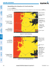
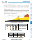
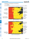
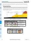
Figure 6-130 Terrain-SVS Page
Yellow Terrain
(Between 100’
and 1000’ Below
the Aircraft
Altitude)
Terrain Legend
Map Range Rings
Map Orientation
Current Aircraft
GPS-derived GSL
Altitude
Red Terrain
(Above or Within
100’ Below the
Aircraft Altitude)
Black Terrain
(More than 1000’
Below the Aircraft
Altitude)
Red Lighted Obstacle
(Above or Within
100’ Below Aircraft
Altitude)
Yellow Lighted Obstacles
(Between 100’ and 1000’
Below Aircraft Altitude)
Annunciation
Window
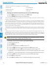
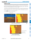
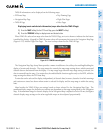
Figure 6-131 Terrain-SVS Page (ARC View)
Yellow Terrain
(Between 100’ and
1000’ Below the
Aircraft Altitude)
Red Terrain
(Above or Within
100’ Below the
Aircraft Altitude)
Black Terrain
(Terrain More
than 1000’ Below
the Aircraft
Altitude)
Map Range Arc
Terrain Legend
Map Orientation
Current Aircraft
GPS-derived GSL
Altitude
Red Lighted Obstacle
(Above or Within
100’ Below Aircraft
Altitude)
Annunciation
Window