


Garmin G1000 Pilot’s Guide for Cessna Nav III
190-00498-07 Rev. A
SYSTEM
OVERVIEW
FLIGHT
INSTRUMENTS
EIS
AUDIO PANEL
& CNS
FLIGHT
MANAGEMENT
HAZARD
AVOIDANCE
AFCS
ADDITIONAL
FEATURES
APPENDICESINDEX
292
HAZARD AVOIDANCE
ECHO TOPS
NOTE: Echo Tops cannot be displayed with Cloud Tops or NEXRAD data.
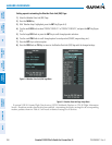
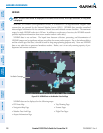
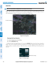
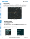
EchoTopsdata(Figure6-14)showsthelocation,elevation,anddirectionofthehighestradarecho.The
highest radar echo does not indicate the top of a storm or clouds; rather it indicates the highest altitude at
whichprecipitationisdetected.InformationisderivedfromNEXRADdata.
Figure 6-14 Echo Tops Data
No Radar Coverage
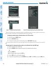
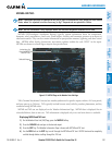
Displaying Echo Tops information:
1) Select the Weather Data Link (XM) Page.
2) Press the ECHO TOP Softkey.
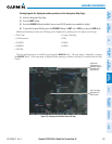
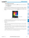
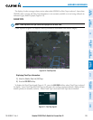
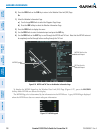
TodisplaytheEchoTopslegend(Figure6-15),presstheLEGENDSoftkeywhenEchoTopsisselectedfor
display.SinceEchoTopsandCloudTopsusethesamecolorscalingtorepresentaltitude,displayofthese
weatherproductsismutuallyexclusive.WhenEchoTopsisactivated,NEXRADandCloudTopsdataare
removed.
Figure 6-15 Echo Tops Legend
No Radar Coverage