


190-00498-07 Rev. A
Garmin G1000 Pilot’s Guide for Cessna Nav III
183
FLIGHT MANAGEMENT
SYSTEM
OVERVIEW
FLIGHT
INSTRUMENTS
EIS
AUDIO PANEL
& CNS
FLIGHT
MANAGEMENT
HAZARD
AVOIDANCE
AFCS
ADDITIONAL
FEATURES
APPENDICES INDEX
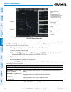
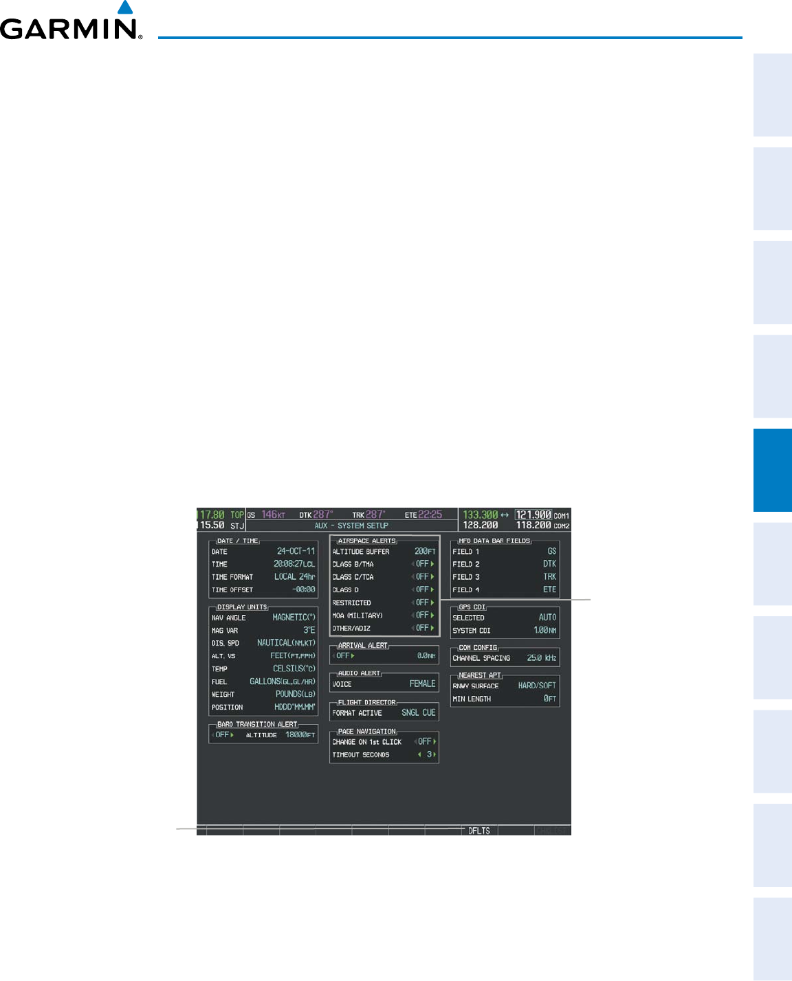
An altitude buffer is also provided which “expands” the vertical range above or below an airspace. For example,
if the buffer is set at 500 feet, and the aircraft is more than 500 feet above/below an airspace, an alert message is
not generated, but if the aircraft is less than 500 feet above/below an airspace and projected to enter it, the pilot
is notified with an alert message. The default setting for the altitude buffer is 200 feet.
Changing the altitude buffer distance setting:
1) Use the FMS Knob to select the AUX - System Setup Page.
2) Press the FMS Knob momentarily to activate the flashing cursor.
3) Turn the large FMS Knob to highlight the altitude buffer field in the Airspace Alerts Box.
4) Use the FMS Knob to enter an altitude buffer value and press the ENT Key.
5) Press the FMS Knob to remove the flashing cursor.
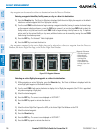
Turning an airspace alert on or off:
1) Use the FMS Knob to select the AUX - System Setup Page.
2) Press the FMS Knob momentarily to activate the flashing cursor.
3) Turn the large FMS Knob to highlight the desired field in the Airspace Alerts Box.
4) Turn the small FMS Knob clockwise to turn the airspace alert ON or counterclockwise to turn the alert OFF.
5) Press the FMS Knob to remove the flashing cursor.
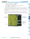
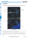
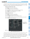
Figure 5-49 System Setup Page - Airspace Alerts
DFLTS Softkey
Airspace Alerts Box
- Airspace Altitude Buffer
- Alert On/Off
(Default Settings Shown)
Map ranges for the airspace boundaries are selected from the Aviation Group in the Map Setup Menu. See Table
5-2 for the default and maximum ranges for each type of airspace and the symbol defining the airspace area.
TheNearestAirspacesPagecanbeusedtoquicklyndairspacesclosetotheightpath.Inaddition,aselected
frequencyassociatedwiththeairspacecanbeloadedfromtheNearestAirspacesPage.Inadditiontodisplaying
a map of airspace boundaries and surrounding area, the Nearest Airspaces Page displays airspace information in
fourboxeslabeled‘AIRSPACEALERTS’,‘AIRSPACE,AGENCY’,‘VERTICALLIMITS’,and‘FREQUENCIES’.