


190-00498-07 Rev. A
Garmin G1000 Pilot’s Guide for Cessna Nav III
18
SYSTEM OVERVIEW
SYSTEM
OVERVIEW
FLIGHT
INSTRUMENTS
EIS
AUDIO PANEL
& CNS
FLIGHT
MANAGEMENT
HAZARD
AVOIDANCE
AFCS
ADDITIONAL
FEATURES
APPENDICESINDEX
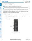
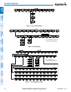
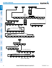
PFD SOFTKEYS
The
CDI
,
IDENT
,
TMR/REF
,
NRST,
and
ALERTS
softkeys undergo a momentary change to black text on
gray background and automatically switch back to white text on black background when selected.
The PFD softkeys provide control over flight management functions, including GPS, NAV, terrain, traffic,
and lightning (optional). Each softkey sublevel has a BACK Softkey which can be selected to return to the
previous level. The ALERTS Softkey is visible at all softkey levels (label changes if messages are issued).
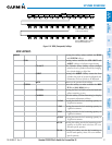
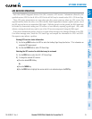
INSET
Displays Inset Map in PFD lower left corner
OFF
Removes Inset Map
DCLTR (3)
Selects desired amount of map detail; cycles through declutter levels:
DCLTR (No Declutter): All map features visible
DCLTR-1: Declutters land data
DCLTR-2: Declutters land and SUA data
DCLTR-3: Removes everything except for the active flight plan
WX LGND
Displays icon and age on the Inset Map for the selected weather products
(optional)
TRAFFIC
Cycles through traffic display options:
TRFC-1: Traffic displayed on inset map
TRFC-2: Traffic Map Page is displayed in the inset map window
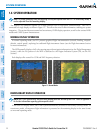
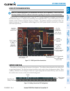
TOPO
Displays topographical data (e.g., coastlines, terrain, rivers, lakes) and elevation
scale on Inset Map
TERRAIN
Displays terrain information on Inset Map
STRMSCP
Displays Stormscope® information on Inset Map
NEXRAD
or
PRECIP
Displays NEXRAD weather and coverage information on Inset Map (optional)
Displays GFDS or FIS-B precipitation on Inset Map (optional)
XM LTNG
or
DL LTNG
Displays XM WX lightning information on Inset Map (optional)
Displays GFDS Worldwide Weather lightning information on Inset Map
(optional)
METAR
Displays METAR flags on airport symbols shown on the Inset Map
(optional)
PFD
Displays second-level softkeys for additional PFD configurations
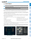
SYN VIS
Displays the softkeys for enabling or disabling Synthetic Vision
features
PATHWAY
Displays rectangular boxes representing the horizontal and vertical
flight path of the active flight plan
SYN TERR
Enables synthetic terrain depiction
HRZN HDG
Displays compass heading along the Zero-Pitch line
APTSIGNS
Displays position markers for airports within approximately 15 nm of
the current aircraft position. Airport identifiers are displayed when
the airport is within approximately 9 nm.
DFLTS
Resets PFD to default settings, including changing units to standard