


Garmin G1000 Pilot’s Guide for Cessna Nav III
190-00498-07 Rev A480
ADDITIONAL FEATURES
SYSTEM
OVERVIEW
FLIGHT
INSTRUMENTS
EIS
AUDIO PANEL
& CNS
FLIGHT
MANAGEMENT
HAZARD
AVOIDANCE
AFCS
ADDITIONAL
FEATURES
APPENDICESINDEX
8.1 SYNTHETIC VISION SYSTEM (SVS) (OPTIONAL)
WARNING:
Use appropriate primary systems for navigation, and for terrain, obstacle, and traffic avoidance.
SVS is intended as an aid to situational awareness only and may not provide either the accuracy or reliability
upon which to solely base decisions and/or plan maneuvers to avoid terrain, obstacles, or traffic.
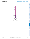
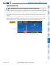
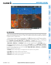
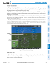
The optional SyntheticVisionSystem(SVS)isavisualenhancementtotheG1000IntegratedFlightDeck.SVS
depictsaforward-lookingattitudedisplayofthetopographyimmediatelyinfrontoftheaircraft.Theeldof
view is 30 degrees to the left and 35 degrees to the right. SVS information is shown on the Primary Flight Display
(PFD),orontheMultifunctionDisplay(MFD)inReversionaryMode(Figure8-91).Thedepictedimageryis
derivedfromtheaircraftattitude,heading,GPSthree-dimensionalposition,andaninearc-seconddatabaseof
terrain, obstacles, and other relevant features. The terrain data resolution of nine arc-seconds, meaning that
theterrainelevationcontoursarestoredinsquaresmeasuringninearc-secondsoneachside,isrequiredforthe
operationofSVS.Lossofanyoftherequireddata,includingtemporarylossoftheGPSsignal,willcauseSVSto
bedisableduntiltherequireddataisrestored.
The SVS terrain display shows land contours (colors are consistent with those of the topographical map display),
largewaterfeatures,towers,andotherobstaclesover200’AGLthatareincludedintheobstacledatabase.Cultural
featuresonthegroundsuchasroads,highways,railroadtracks,cities,andstateboundariesarenotdisplayed
evenifthosefeaturesarefoundontheMFDmap.Theterraindisplayalsoincludesanorth–southeast–westgrid
with lines oriented with true north and spaced at one arc-minute intervals to assist in orientation relative to the
terrain.
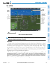
The optional Terrain Awareness andWarning System (TAWS) or standardTerrain-SVS is integrated within
SVS to provide visual and auditory alerts to indicate the presence of terrain and obstacle threats relevant to the
projected flight path. Terrain alerts are displayed in red and yellow shading on the PFD.
Theterraindisplayisintendedforsituationalawarenessonly.Itmaynotprovidetheaccuracyordelityon
which to base decisions and plan maneuvers to avoid terrain or obstacles. Navigation must not be predicated
solelyupontheuseoftheTerrain–SVSorTAWSterrainorobstacledatadisplayedbytheSVS.
The following SVS enhancements appear on the PFD:
•Pathways
•FlightPathMarker
•HorizonHeadingMarks
•TrafcDisplay
•AirportSigns
•RunwayDisplay
•TerrainAlerting
•ObstacleAlerting