


190-00498-07 Rev. A
Garmin G1000 Pilot’s Guide for Cessna Nav III
22
SYSTEM OVERVIEW
SYSTEM
OVERVIEW
FLIGHT
INSTRUMENTS
EIS
AUDIO PANEL
& CNS
FLIGHT
MANAGEMENT
HAZARD
AVOIDANCE
AFCS
ADDITIONAL
FEATURES
APPENDICESINDEX
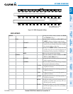
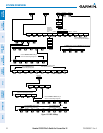
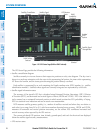
MAP
Enables second-level Navigation Map softkeys
TRAFFIC
Displays traffic information on Navigation Map
PROFILE
Displays/removes Profile View on Navigation
Map Page
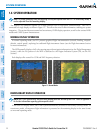
TOPO
Displays topographical data (e.g., coastlines,
terrain, rivers, lakes) and elevation scale on
Navigation Map
TERRAIN
Displays terrain information on Navigation Map
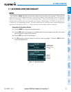
AIRWAYS
(Default label
is dependant
on map setup
option selected)
Displays airways on the map; cycles
through the following:
AIRWAYS: No airways are displayed
AIRWY ON: All airways are displayed
AIRWY LO: Only low altitude airways
are displayed
AIRWY HI: Only high altitude airways
are displayed
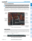
STRMSCP
Pressing this softkey displays/removes Stormscope
lightning data on the Navigation Map.
NEXRAD
or
PRECIP
Displays NEXRAD weather and coverage
information on the Navigation Map (optional)
Displays GFDS or FIS-B precipitation on
Navigation Map (optional)
XM LTNG
or
DL LTNG
Displays XM WX lightning information on
the Navigation Map (optional)
Displays GFDS Worldwide Weather
lightning information on the Navigation
Map (optional)
METAR
Displays METAR flags on airport symbols
shown on the Navigation Map
LEGEND
Displays the legend for the selected weather
products. Available only when NEXRAD,
XM LTNG, METAR and/or PROFILE
softkeys are selected.
BACK
Returns to top-level softkeys
DCLTR (3)
Selects desired amount of map detail; cycles
through declutter levels:
DCLTR (No Declutter): All map features visible
DCLTR-1: Declutters land data
DCLTR-2: Declutters land and SUA data
DCLTR-3: Removes everything except for the
active flight plan
SHW CHRT
Displays the appropriate chart
CHKLIST
Displays the Checklist Page