


26 GPSMAP 700 Series Owner’s Manual
Navigation
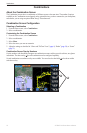
Courses
You can set and follow a course to a destination using one of three methods: Go To, Route To, or Guide To.
• —takes you directly to the destination.
• —creates a route from your location to a destination, allowing you to add turns along the way.
• —uses BlueChart g2 Vision chart data to suggest the best path to your destination using Auto
Guidance. You must be using a BlueChart g2 Vision data card for this option to appear.
Setting and Following a Direct Course Using Go To
CAUTION
When using Go To, a direct course and a corrected course may pass over land or shallow water. Use visual
sightings and steer to avoid land, shallow water, and other dangerous objects.
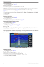
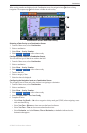
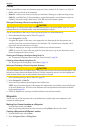
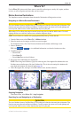
You can set and follow a direct course from your present location to a selected destination.
1. Select a destination using a chart or Where To? (page 25).
2. Select > .
A magenta line appears. In the center or the magenta line is a thinner purple line that represents the
corrected course from your present location to the destination. The corrected course is dynamic, and it
moves with your boat when you are off course.
3. Follow the magenta line, steering to avoid land, shallow water, and other obstacles.
: If you are off course, follow the purple line (corrected course) to go to your destination, or steer
back to the magenta line (direct course).
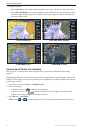
Creating and Following a New Route Using Route To
See “Creating and Navigating a Route from Your Present Location” (page 28).
Following a Saved Route Using Route To
See “Browsing for, and Navigating, a Saved Route” (page 34).
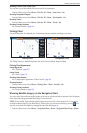
Setting and Following a Course Using Auto Guidance
CAUTION
The Auto Guidance feature of the BlueChart g2 Vision data card is based on electronic chart information. That
data does not ensure obstacle and bottom clearance. Carefully compare the course to all visual sightings and
avoid any land, shallow water, or other obstacles that may be in your path.
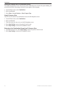
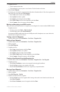
1. Select a destination using a chart or Where To? (page 25).
2. Select > .
3. Review the course indicated by the magenta Auto Guidance line.
: A gray line within any part of the magenta line indicates that Auto Guidance cannot calculate part
of the Auto Guidance line. This is due to the minimum safe water depth and the minimum safe obstacle
height settings (page 46).
4. Follow the magenta line, steering to avoid land, shallow water, and other obstacles.
Waypoints
You can store up to 3,000 waypoints with a user-dened name, symbol, depth, water temperature, and
comment for each waypoint.
Marking Your Present Location as a Waypoint
From the Home screen, select .
Mark your present position from any other screen by touching at the top of the screen.
Creating a Waypoint at a Different Location
1. From the Home screen, select
2. Select or .