


6 GPSMAP 700 Series Owner’s Manual
Charts and 3D Chart Views
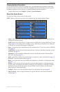
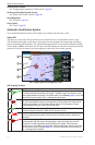
Conguring the Appearance of Waypoint Symbols
1. From the Home screen, select .
2. Select or .
3. Select > > .
4. Select a waypoint symbol.
5. Complete an action:
• Select to display the name and symbol.
• Select to display only the symbol.
• Select to display any comments you have added (page 27).
• Select to hide the symbol.
Setting the Color of the Active Track
See (page 31).
Showing or Hiding Colored Tracks
You can specify the color of tracks (page 31) and then show or hide all tracks of that color.
1. From the Home screen, select .
2. Select or .
3. Select > > .
4. Select a color to show or hide all tracks of that color.
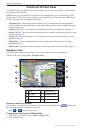
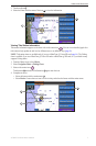
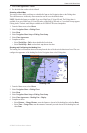
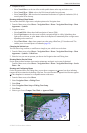
Viewing Location and Object Information on a Chart
You can view information about a location or an object on the Navigation chart or the Fishing chart.
1. From the Home screen, select .
2. Select or .
3. Touch a location or an object.
A list of options appears along the right side of the chart. The options that appear vary based on the
location or object you selected.
4. Complete an action:
• Select to view details of objects in the vicinity of the cursor. ( does not appear if the
cursor is not near an object. If the cursor is near only one object, the name of the object appears.)
• Select to navigate to the selected location (page 5).
• Select to mark a waypoint at the cursor location.
• Select to view the distance and bearing of the object from your present location. The
information appears in the upper-left corner of the screen. Select to measure from the
selected location, rather than your present location.
• Select to view tide (page 36), current (page 37), celestial (page 38), chart notes, or local
services information near the cursor.
• Select to remove the pointer from the screen. Select to stop panning and
return the screen to your present location.
Viewing Additional Object Information
You can view information about on-screen map items, waypoints, and charts.
: Mariner’s Eye 3D and Fish Eye 3D chart views are available only if you use a BlueChart g2 Vision
SD card (page 16). The Fishing chart is available if you use a BlueChart g2 Vision SD card or a BlueChart g2
SD card, or if your built-in map supports Fishing charts.
1. From the Home screen, select .
2. Select a chart or a 3D chart view.