


14 GPSMAP 700 Series Owner’s Manual
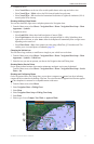
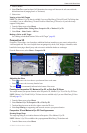
Charts and 3D Chart Views
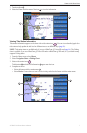
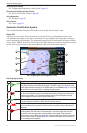
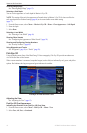
Showing AIS Vessels on a Chart or on a 3D Chart View
AIS requires the use of an external AIS device and active transponder signals from other vessels.
You can congure how other vessels appear on a chart or on a 3D chart view. The display range congured
for one chart or one 3D chart view is applied only to that chart or to that 3D chart view. The details, projected
heading, and trails settings congured for one chart or one 3D chart view are applied to all charts and to all 3D
chart views.
: The Mariner’s Eye 3D chart is available if you use a BlueChart g2 Vision SD card. The Fishing chart
is available if you use a BlueChart g2 Vision SD card or a BlueChart g2 SD card, or if your built-in map
supports Fishing charts.
1. From the Home screen, select .
2. Select , , , or .
3. Select > > .
4. Complete an action:
• Select to indicate the distance from your location within which AIS vessels appear.
Select a distance or select .
• Select > to show details about AIS-activated vessels.
• Select , enter the projected heading time for AIS-activated vessels, and select .
• Select to show the tracks of AIS vessels, and select the length of the track that appears using a
trail.
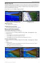
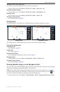
Activating a Target for an AIS Vessel
1. From the Home screen, select .
2. Select , , , or .
3. Touch an AIS vessel.
4. Select > .
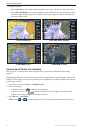
Viewing Information about a Targeted AIS Vessel
You can view the AIS signal status, MMSI, GPS speed, GPS heading, and other information that is reported
about a targeted AIS vessel.
1. From the Home screen, select .
2. Select , , , or .
3. Touch an AIS vessel.
4. Select .
Deactivating a Target for an AIS Vessel
1. From the Home screen, select .
2. Select , , , or .
3. Touch the AIS vessel.
4. Select > .
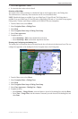
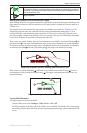
Setting the Safe-zone Collision Alarm
The safe-zone collision alarm is used only with AIS. The safe zone is used for collision avoidance, and can be
customized. All safe-zone collision alarm settings are applied to all charts, to all 3D chart views, to all radar
modes, and to the Radar Overlay.
1. From the Home screen, select > > > .
A message banner appears and an alarm sounds when an AIS-activated vessel enters the safe-zone ring
around your boat. The object is also labeled as dangerous on the screen. The setting disables the
message banner and the audible alarm, but the object is still labeled as dangerous on the screen.
2. Select to set the measured radius of the safe-zone ring to a specied distance from 500 ft. to 2.0 nm
(or from 150 m to 3.0 km, or from 500 ft. to 2.0 mi.).