


16 GPSMAP 700 Series Owner’s Manual
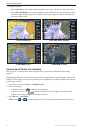
Charts and 3D Chart Views
2. Select or .
3. Select > > > .
Selecting a Lane Width
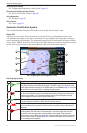
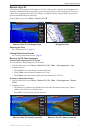
The navigation lane is the magenta line in Perspective 3D or Mariner’s Eye 3D view that indicates the course
to your destination while you are navigating. You can specify the width of the navigation lane.
: Mariner’s Eye 3D is available with a preprogrammed BlueChart g2 Vision data card.
1. From the Home screen, select .
2. Select or .
3. Select > > .
4. Enter the width.
5. Select .
Showing Other Vessels
See “Conguring the Appearance of Other Vessels” (page 50).
Showing and Conguring Data Overlay
See “Overlay Numbers” (page 48).
Using Waypoints and Tracks
See “Waypoints” (page 26) or “Tracks” (page 30).
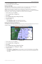
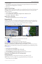
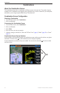
BlueChart g2 Vision
An optional, preprogrammed BlueChart g2 Vision data card allows you to get the most out of your chartplotter.
In addition to detailed marine charting, BlueChart g2 Vision has the following features:
• (page 17)—provides a view from above and behind the boat for a three-dimensional
navigation aid. The BlueChart g2 Vision Mariner’s Eye 3D is more detailed than the pre-loaded data.
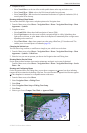
• (page 18)—provides an underwater, three-dimensional view that visually represents the
sea oor according to the information on the chart.
• (page 19)—shows the chart with enhanced bottom contours and without navigational data.
This chart works well for offshore deep-sea shing.
• (page 19)—provides high-resolution satellite images for a realistic
view of the land and water on the Navigation chart.
• (page 20)—shows marinas and other navigationally signicant aerial photos to help you
visualize your surroundings.
• (page 21)—shows roads, restaurants, and other points of interest (POIs)
along the shore.
• (page 21)—uses specied safe depth, safe height, and chart data to determine the best
course to your destination.
BlueChart g2 Vision Data Cards
NOTICE
BlueChart g2 Vision data cards are not waterproof. When you are not using the card, keep it in the original
packaging for safekeeping and store it away from exposure to sun and rain to prevent damage to the card.
BlueChart g2 Vision data cards are susceptible to damage from static electricity. In low-humidity
environments, you should ground yourself on a large metal object before handling the card to prevent damage
to the card.
You cannot transfer BlueChart g2 Vision data from the data card to your computer for backup or viewing
purposes. You can use the data card only on BlueChart g2 Vision-compatible Garmin GPS units or Garmin
HomePort
™
.
You can insert or remove a BlueChart g2 Vision data card (page 2) while your chartplotter is on or off.