


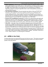


4 GPS
14 CONTENTS TM-D710A/E
4.1.2 Datum (Geodetic Survey System)
The latitude and longitude information required by the GPS receiver does not allow for accurate
representation of the unevenness of the Earth’s surface. For use with GPS, the current standard
that defines the precise shape of the Earth is called WGS-84. By using this standard in
conjunction with mapping standards for each country, accurate position plotting on a map can be
done.
4.1.2.1 GPS and APRS Position Format
Although position can be described in many different formats, such as degrees, degrees and
minutes, and degrees, minutes and seconds, the GPS system and APRS have standardized on
the degrees and decimal minutes format. Just like it is important to use proper international
phonetics when spelling on the air, it is important in APRS as in any communications system to
have a default standard for position. All operators should be trained to use the DDD MM.mm
format by default in voice communications just like in the data formats. Using these standards on
the air will prevent communications errors, confusion, repeats, and conversions.
APRS Standard:
Geographic
Coordinates
Format Example
Latitude
DD MM.mm
(degrees and minutes)
39 49.31N
+39 49.31
Longitude
DDD MM.mm
(degrees and minutes)
84 15.39W
-84 15.39