


– 7 –
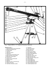
ALIGNING THE VIEWFINDER
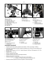
The wide field of view provided by the 5 x 24mm viewfinder (17, Fig. 1) permits easy object sighting prior to
observation in the higher-power main telescope. To align the viewfinder, follow this procedure:
1. First remove the dust cap (
21, Fig. 1, not visible in photo) from the dew shield/lens shade (22, Fig. 1).
Then using the lowest power (25mm) eyepiece, point the main telescope at some well defined land
target (
e.g. the top of a telephone pole) at least 200 yards distant.
2. Look through the viewfinder and tighten or loosen, as appropriate, the viewfinder’s 6 collimation screws
(16, Fig. 1 and Fig. 4), until the cross hairs of the viewfinder are precisely centered on the same object
already centered in the main instrument’s field of view.
Hint: Center the front of the viewfinder in the
bracket using the 3 front ring thumbscrews, then make final object centering adjustments with the 3 back
ring thumbscrews.
3. With this alignment accomplished, objects located first in the wide-field viewfinder will then be centered
in the main telescope’s field of view. Focusing of objects in the viewfinder is accomplished by turning the
threaded eyepiece of the viewfinder. (
Note: The viewfinder presents an image which is upside-down;
this is customary in all astronomical viewfinders).
BALANCING THE TELESCOPE
In order for the telescope to move smoothly on its mechanical axes, it must first be balanced as follows:
Note: If the counterweight is positioned as recommended on the previous page—the telescope is already
approximately balanced.
1. Loosen the Right Ascension lock (26, Fig. 1). With the R.A. lock loosened, the telescope mount will turn
freely about the polar axis. Rotate the telescope about the polar axis so that the counterweight shaft (
30,
Fig. 1) is parallel to the ground (horizontal).
2. Loosen the counterweight’s locking thumb screw (29, Fig. 1) and slide the counterweight (28, Fig. 1)
along the shaft until the telescope remains in any given position without tending to drift up or down the
polar axis. Then retighten the counterweight lock.
The telescope is now balanced.
UNDERSTANDING CELESTIAL MOVEMENTS AND COORDINATES
Understanding where to locate celestial objects and how those objects move across the sky is the key to
enjoying the hobby of astronomy. Most amateur astronomers practice “star-hopping” to locate celestial
objects. They use star charts or astronomical software to identify bright stars and star patterns as
“landmarks” in their search for astronomical objects. Another technique for locating objects is use the setting
circles that are provided on your telescope. See Step #6, page 9.
Understanding how astronomical objects move: Due to the Earth’s rotation, celestial bodies appear to
move from East to West in a curved path through the skies.
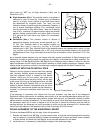
All stars and celestial objects are mapped onto an imaginary sphere surrounding the Earth. This mapping
system is similar to the system of latitude and longitude on Earth surface maps.
In mapping the surface of the Earth, lines of longitude are drawn between the North and South Poles and
lines of latitude are drawn in an East-West direction, parallel to the Earth’s equator. Similarly, imaginary lines
have been drawn to form a latitude and longitude on the celestial sphere. These lines are known as
Right
Ascension
and Declination. The path an object follows through the sky is known as Right Ascension (R.A.).
The angle of this path an object follows is known as Declination (Dec.).
The celestial map also contains two poles and an equator just like a map of the Earth. The celestial poles
are defined as those two points where the Earth’s North and South poles, if extended to infinity, would cross
the celestial sphere. Thus, the North Celestial Pole (see
Fig. 8) is that point in the sky where the North Pole
intersects the celestial sphere. The North Star, Polaris, is located very near the North Celestial Pole. The
celestial equator is a projection of the Earth’s equator onto the celestial sphere.
So just as an object's position on the Earth’s surface can be located by its latitude and longitude, celestial
objects may also be located using Right Ascension and Declination.
For example: You can locate Los
Angeles, California, by its latitude (+34°) and longitude (118°). Similarly, you can locate the Ring Nebula