


73
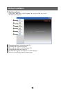
Map settings
The following map display settings are configurable.
In the menu display, touch c “Map” c the desired item c the desired option.
Item Purpose
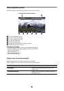
2D / 3D Map View Selects the default map view.
–“2D”: Overhead view.
–“3D” (level 1): Aerial view (high angle).
–“3D” (level 2): Aerial view (medium angle).
–“3D” (level 3): Aerial view (low angle).
Map Orientation Selects the default orientation of 2D map.
–“In Direction of Travel”: Heading up.
–“Always North”: North up.
Map Color Selects the map color schemes for day time
use and night time use.
Automatic Map Color Change Switches the map color scheme automatically.
Preset Scale (page 9) Presets the map scale level for clockwise and
counterclockwise circles of Gesture
Command.
Landmark Icon Shows landmark icons on the map.
The settings can be configured separately for
each facility.
Driving Trail Shows driving trail on the map: “ON,” “OFF.”
Delete Driving Trail Deletes driving trail.
Address Book Icon Shows the address book entry icons on the
map: “ON,” “OFF.”
Always Show Traffic Button
(NV-U94T/U74T only)
Always shows the traffic icon on the map:
“ON,” “OFF.”
Road Width Selects the width of the road shown on the
map: “Wide,” “Standard.”
Font Size Selects the size of the fonts shown on the
map: “Large,” “Medium,” “Small.”
Icon Size Selects the size of the icons shown on the
map: “Large,” “Medium,” “Small.”
Zoom While Scrolling Zooms out the map/fixes the scale when
scrolling: “ON,” “OFF.”
Compass and Speedometer Shows the current speed and direction on the
map when no route guidance is in progress:
“ON,” “OFF.”
Map Version Views the version of the current map.