


vi Rino
®
520/530 Owner’s Manual
INTRODUCTION > TABLE OF CONTENTS
Introduction .............................................................i
Getting to Know Your Rino 520/530 .....................
1
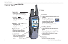
Front of the Rino 520/530 ........................................2
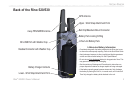
Back of the Rino 520/530 .........................................3
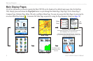
Main Display Pages ..................................................4
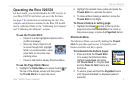
Operating the Rino 520/530 .....................................5
Status Bar Overview ................................................6
Unit Operation ........................................................7
Radio Page ................................................................7
Initializing the Rino 520/530 ......................................... 7
Using Name and Symbol Fields ....................................8
Setting the Channel and Code .....................................10
Adjusting the Volume and Squelch Level: .................. 11
Scanning and Monitoring ............................................12
Radio Page Option Menu ............................................13
Setup Radio ............................................................ 14
Setup Tones ............................................................16
Use Weather Radio ....................................................17
Use Weather Alert .................................................. 17
Turn Radio/GPS On/Off ........................................ 18
Status Window .............................................................18
GPS Status .............................................................18
Radio Transmission/Reception Status ...................18
Using the Rino 520/530 Radio Features ...............20
Peer-to-Peer Positioning ..............................................20
New Contact Page Overview .......................................20
Sending a Location ......................................................23
Map Page .................................................................24
Map Page Options .......................................................26
Using the Pan Map Option ..........................................27
Programming the Data Fields ......................................28
Setting up the Map .......................................................29
Measuring Distance ..................................................... 31
Compass Page ........................................................32
Using the Compass Page .............................................32
Compass Page Options ................................................34
Using Sight ‘N Go ......................................................35
Calibrating the Compass ..............................................35
Altimeter Page .......................................................37
Altimeter Page Options ...............................................38
Viewing Pressure/Elevation Plots ................................39
Adjusting the Zoom Ranges ........................................39
Pan Plot ........................................................................ 40
Resetting Data ..............................................................40
Calibrating the Altimeter ............................................. 41
Programming Data Fields ............................................ 41
Main Menu Page .....................................................42